Place · Cusco, Peru
Cusco
The Inca capital, where a sun temple's walls still carry a church, lines of shrines once ran out to the mountains, and Quechua festivals go on.
Visited May 2024

Sources
On the way
Overview
Cusco sits at about 3,400 meters in a fertile valley of the southern Peruvian Andes. It was the capital of Tawantinsuyu, the Inca state, which held much of the Andes in the 15th and early 16th centuries.1 In Quechua the city is Qusqu or Qosqo.2 People lived in the valley long before the Inca. UNESCO counts more than 3,000 years of earlier occupation.1
Inca tradition credits the ruler Pachacuti with rebuilding Cusco in the 15th century as a royal and sacred center.1 At its heart stood the Qorikancha (also spelled Coricancha; Quechua Quri Kancha, "golden enclosure"), the temple of the Sun. From it, according to accounts written soon after the Spanish conquest, 41 or 42 imagined lines called ceques ran out across the valley, and along them lay at least 328 shrines.34 The Quechua word for such a shrine is huaca (also spelled wak'a). A huaca could be a spring, a boulder, a cave, a hilltop or a building: any place or thing that held sacred power.4
The Spanish entered the city in 1533 and built churches and houses on top of the Inca walls.12 Earthquakes in 1650 and 1950 brought down much of the colonial city, and the 1950 quake exposed Inca walls that had been hidden for centuries.5 Today Cusco is a layered place. It has Inca foundations, baroque churches, and a regional population in which more than half learned an Indigenous language, mostly Quechua, as children.16
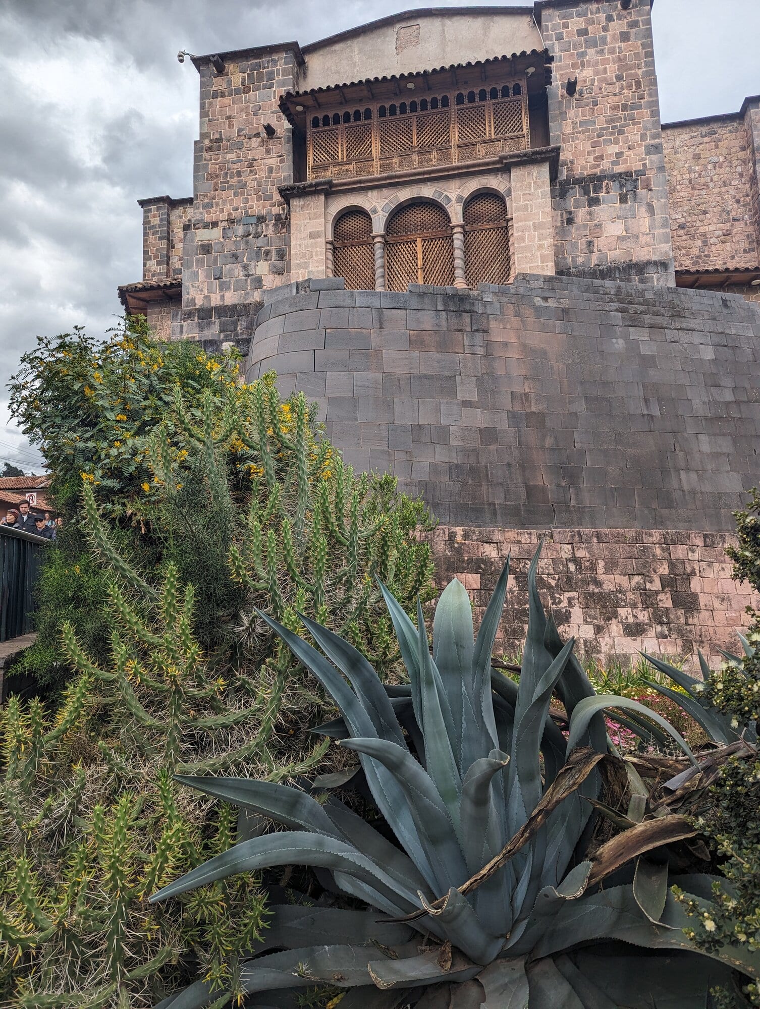
The Qorikancha's curved Inca wall, with the church and convent of Santo Domingo built on top of it, May 2024.
- The curved Inca wall at the west end of the temple
- Santo Domingo, built on the temple after the conquest and rebuilt after 1650
- 1000 Killke period Killke pottery marks the centuries in which the Inca state took shape in the valley, about AD 1000 to 1400.
- 1438 Pachacuti (traditional date) The date usually given for the ruler who rebuilt Cusco; radiocarbon dates elsewhere suggest it was earlier.
- 1533 The Spanish arrive Francisco Pizarro enters Cusco in November; the temple gold goes to Atahualpa's ransom.
- 1650 Earthquake A great quake leaves the colonial city in ruins; Inca walls mostly stand.
- 1950 Earthquake The quake of 21 May damages a third of the city and exposes the Qorikancha's walls.
In context
The Andes were full of sacred places. The Inca saw the land as "charged with sacred energy" and honored unusual stones, ridges and streams as huacas.4 The art historian Carolyn Dean argues that Inca rock has to be seen the way the Inca saw it: as something that could be alive, aware and sacred. Building in stone was, for them, a way to bring order to wild nature and to claim new ground.7
Cusco was the center of this sacred map. Tawantinsuyu means "the four parts together," and the four parts, or suyus, met at the Qorikancha. The city itself was split into two halves, Hanan (upper) to the north and Hurin (lower) to the south, each holding two of the suyus.8 Social life was organized by ayllus, extended kin groups that held land and duties in common. Particular kin groups looked after particular huacas.8
Most of what is written about Inca Cusco comes from Spanish and mestizo authors after the conquest: Juan de Betanzos (1551), Pedro Cieza de León (1553), Pedro Sarmiento de Gamboa (1572), Garcilaso de la Vega (1609) and Bernabé Cobo (1653), among others. Each had his own sources and purposes. Sarmiento, for example, wrote in Cusco for the viceroy's government, and his history was sent to Philip II.9 Archaeology tests these accounts and sometimes moves their dates. Radiocarbon dates from Machu Picchu, for instance, show the site in use from about AD 1420, around two decades before the traditional date for Pachacuti's rise.10
Several books in the Library go further into Cusco and the Andes.
Research
Before the Inca
The Cusco valley was settled long before the Inca rose. UNESCO's statement for the site speaks of "3,000 years of indigenous and autonomous cultural development" in the southern Andes.1 The archaeologist Brian Bauer's survey of the valley runs from the first hunter-gatherers through the Archaic, Formative and Wari periods to the Inca.11 In the Middle Horizon (roughly AD 600 to 1000), the Wari state, centered far to the northwest, built a large walled site at Pikillacta in the Lucre Basin, at the eastern end of the Cusco valley.12
The people who lived around Cusco just before the Inca empire are usually called the Killke. The name comes from a pottery style first described by the archaeologist John H. Rowe: round vessels with strap handles and simple black or black-on-red geometric designs.13 Dates for Killke vary by source. A common figure is AD 900 to 1200,13 while Bauer and Alan Covey treat AD 1000 to 1400 as the Killke period, during which the Inca state formed in the valley.1114
In 2008 archaeologists working near Sacsayhuamán reported a temple with eleven rooms, thought to have held mummies and idols, along with a buried roadway and water channels. The team believed the buildings were older than the Inca empire and later enlarged by the Inca. Carbon dates were still pending. The same report cited the archaeologist Luis Lumbreras for earlier radiocarbon dates suggesting that Killke builders began the hilltop complex in the 1100s.15 This is a press account, and the dates have not been traced here to a published report.
The city and the puma
Cusco is often said to be laid out in the shape of a puma, with Sacsayhuamán as the head, the great plaza as the body, and the tail where two rivers meet.16 The idea has a real source. Sarmiento, writing in 1572, says that Tupac Inca Yupanqui "remembered that his father Pachacuti had called the city of Cuzco the lion city." He goes on: "the tail was where the two rivers unite which flow through it, ... the body was the great square and the houses round it, and ... the head was wanting." The Inca and his nobles decided the best head would be a fortress on the hill to the north.9 "Lion" here is the Spanish word for the puma. The district at the river junction is still called Pumachupan, "the puma's tail."9
In the 1960s Rowe published the case that Inca Cusco was planned on the profile of a puma, building on a suggestion from the Cusco archaeologist Manuel Chávez Ballón and on the accounts of Betanzos and Sarmiento.17 The idea has spread widely since.1816
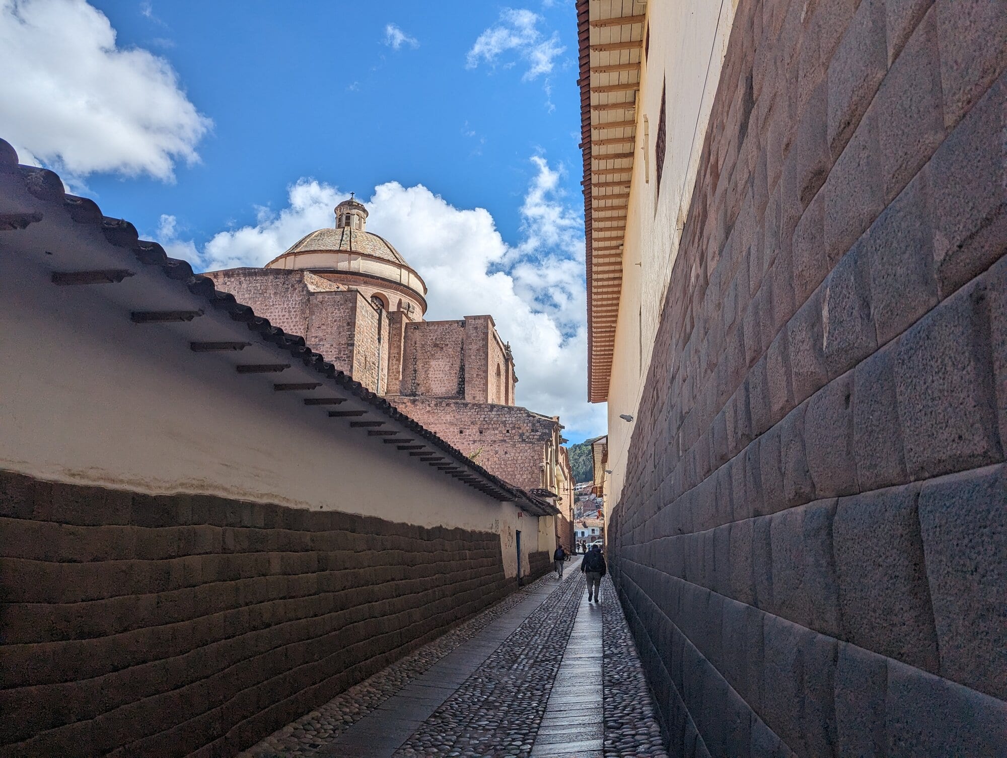
A narrow street in the old center, lined with Inca walls, April 2024. Many of Cusco's streets still follow Inca lanes.
- Fitted Inca stonework, the base of a later building
- A church dome at the end of the street
Deep Dive: How strong is the puma plan?
The firm part is that the Inca themselves used the puma as an image for their city. Sarmiento records it, and the place name Pumachupan has survived.9 Rowe's reading drew on Betanzos's and Sarmiento's naming of the city's parts.17
Several things counsel caution. Sarmiento says Pachacuti "called" the city the lion city. That reads at least as easily as a figure of speech as it does a surveyed outline. In the same passage the head is missing until the next ruler adds Sacsayhuamán, so the "puma" was not drawn in one stroke.9 Archaeological work also points to slower, more organic growth of the city, starting before Pachacuti.2 The astronomer Giulio Magli, who discusses the idea, presents it as "a long-standing tradition."18 Other writers have proposed different animals, such as a llama, for the same plan (see Sources to check below).
The images of a cat laid over a map of Cusco that appear in guidebooks are modern drawings. A fair summary is that the puma was an Inca way of speaking about the city, and perhaps of thinking about it. Whether the streets were laid out to trace a puma's body is unproven.
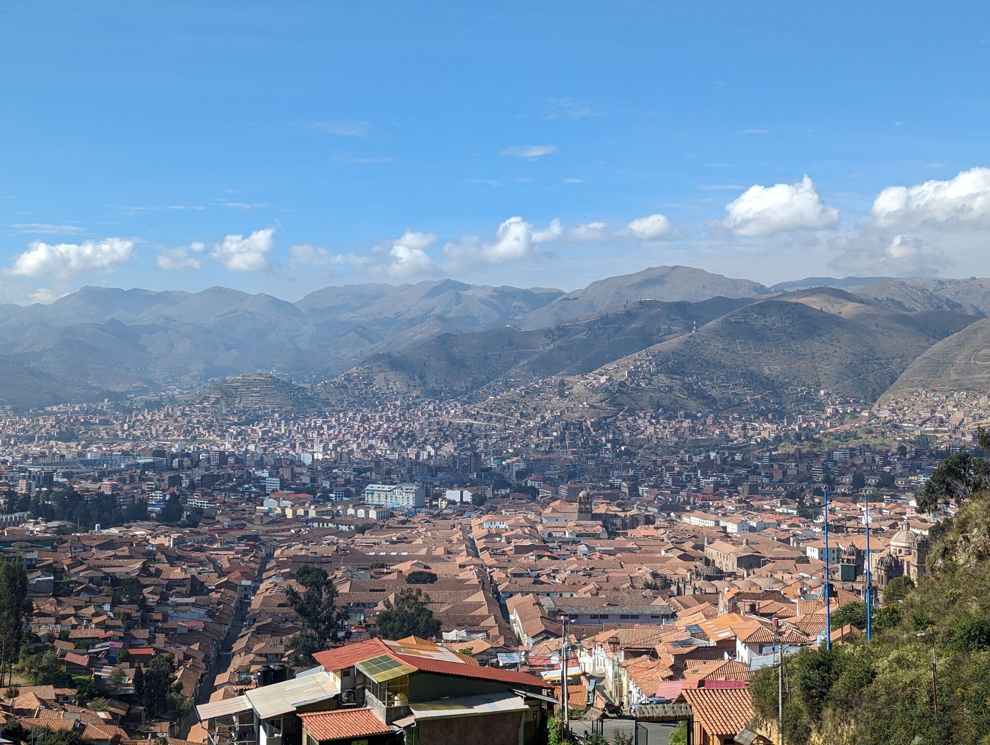
Cusco from the hills above the city, May 2024. The old center lies in the valley floor, with newer districts climbing the slopes beyond.
The Qorikancha
The Qorikancha was the most important temple in the Inca state. Its older names were Intikancha or Intiwasi, "enclosure" or "house" of Inti, the Sun.19 Sarmiento credits Pachacuti with rebuilding the House of the Sun.9 Spanish writers described walls covered in sheets of gold and a courtyard filled with golden figures. In 1533 most of the gold for Atahualpa's ransom was taken from here.19 Pizarro's secretary, Pedro Sancho, recorded "five hundred-odd" gold plates torn from the walls in 1533.20 The bodies of earlier rulers were kept in the temple, dressed and seated, and brought out for festivals.19
The temple is built of ashlar, stone cut into regular, squared blocks laid in even courses. Ashlar is hard to work because a chipped block cannot easily be reshaped, and the Inca used it for their most sacred buildings, such as the Qorikancha and the Acllawasi, the house of the chosen women.21 The temple also has one of the few curved Inca walls, at its west end, where the Inca masonry now forms the base of the church.21 The site lies near the meeting of two rivers, which the astronomer Ed Krupp reads as the earthly pivot of the Inca heavens.19
After the conquest the Dominican order built its church and convent on the temple; the sources give its founding as 1534 or 1538.2223 The first convent was destroyed in the 1650 earthquake and rebuilt.19 The 1950 earthquake damaged the church badly and exposed the Inca walls inside it.216 Restoration then uncovered more of the Inca masonry. Four rooms of the temple survive inside the convent.1922
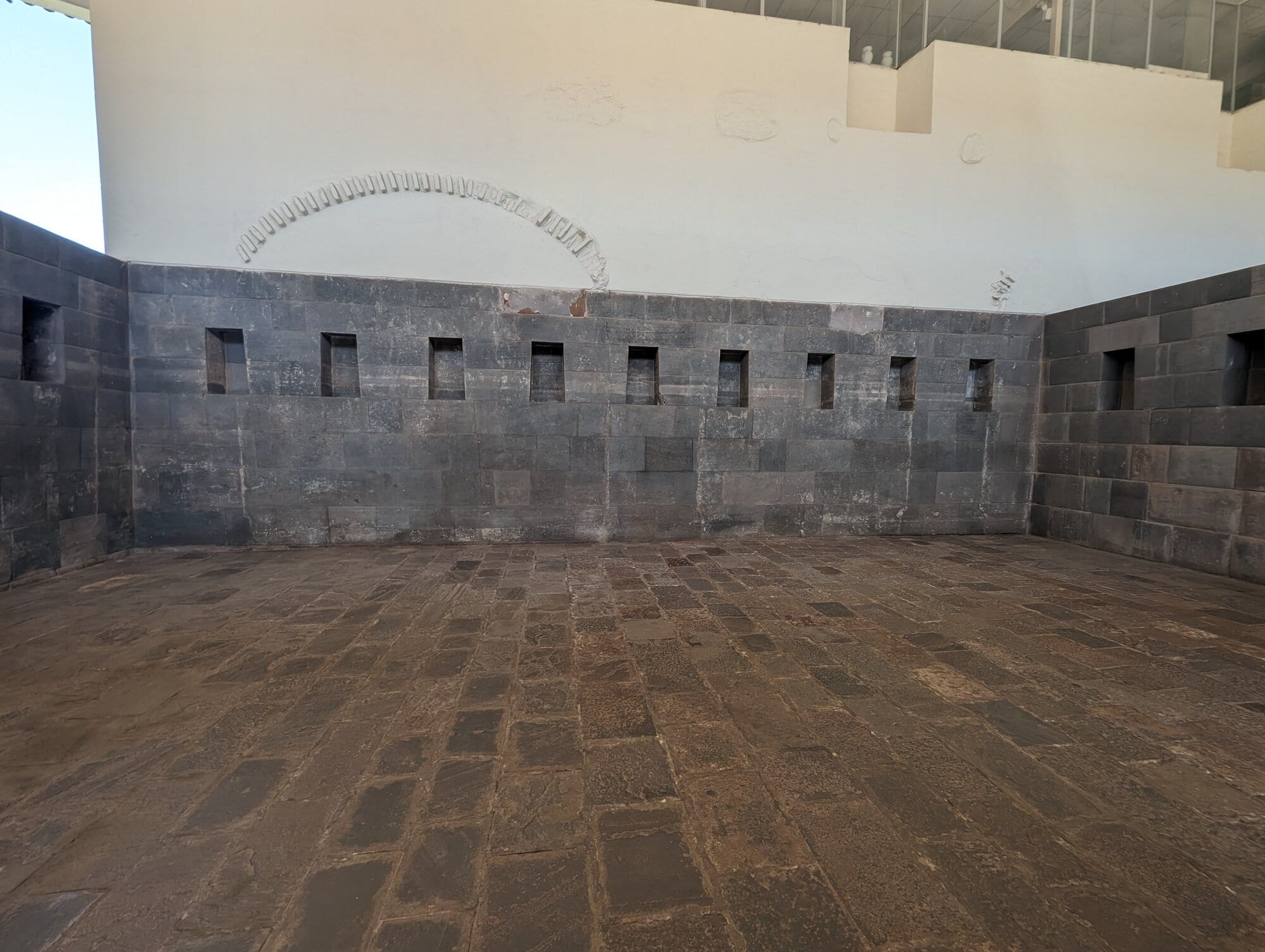
One of the Inca rooms preserved inside the Qorikancha, May 2024.
- A row of trapezoidal niches, narrower at the top than at the bottom
- The stone floor of the room
Deep Dive: The Qorikancha: rooms, gold and ruin
What is known of the Qorikancha's interior comes from three kinds of source, and they deserve different amounts of trust. The earliest are Spanish accounts from the 1530s to 1550s, by men who saw the temple or spoke with those who did. The fullest is the Royal Commentaries of Garcilaso de la Vega, published in 1609 by a writer born in Cusco in 1539 to an Inca noblewoman and a Spanish captain, working in Spain from boyhood memory. The third is the archaeology of what survives, which is less than the walls suggest.
The plan. Pedro Cieza de León, who was in Cusco around 1550, describes an enclosure "more than four hundred paces in circuit," surrounded by a strong wall of finely fitted stone, with a band of gold running round it halfway up.24 Inside, buildings with thatched roofs stood around a central courtyard. Garcilaso puts the gold band at the top of the wall, as a cornice more than a yard wide. He adds that the Spaniards later replaced it with a band of white plaster "in memory of the former one," which he saw.25 The western end of the enclosure is the curved wall that now carries the church. It stands higher than the rest because it is built against the slope of the hill, like a balcony over the ground below.26 Below it, terraces step down to a sloping lawn above Avenida El Sol. This was the friars' vegetable garden in Garcilaso's day.25
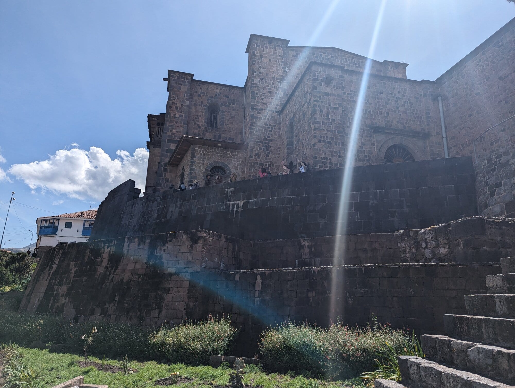
The Inca terrace walls below the church, May 2024.
- Inca terrace walls stepping down the slope
- The church of Santo Domingo above
Water ran through the complex. Garcilaso writes that there were five fountains with gold pipes, used to wash offerings. Only one still worked in his youth, watering the convent garden, until a flood in 1558 broke its buried pipe.25 In one of the surviving rooms a block has three holes cut through it, often read as a drain for rain or poured offerings of chicha (maize beer).19
The shrines. Garcilaso gives the room-by-room account that guides still follow. The main temple held a gold image of the Sun, a face with rays made from a single thick plate, wide enough to fill one wall. The mummies of past rulers sat on gold seats on either side, with Huayna Capac facing the image. Around a cloister stood five separate halls with pyramid-shaped roofs. The hall of the Moon, Mama Killa, was lined with silver and held the mummies of the queens. A second silver hall belonged to Venus, which he calls Chasca, "the one with long and curly hair," and to the Pleiades and the other stars, with a ceiling strewn with stars. A gold-lined hall honored Illapa, a single word for thunder, lightning and the thunderbolt. Another gold hall had a rainbow painted across its plates. The fifth was a meeting hall for the high priest, the Villac Umu, and his assistants.25
The earlier writers are less tidy. Cieza counts four houses, with the Sun's figure in the richest one.24 Garcilaso insists the Sun was the only image in the temple. Sarmiento de Gamboa, writing in 1572, says Pachacuti also made gold images of the creator Viracocha and of lightning, Chuqui Illa, and set them beside the Sun.9
Archaeology can confirm the courtyard plan but not the dedications. Ian Farrington's 2013 synthesis counts nine buildings, eight of them opening onto the patio. Only two survive well enough to read their layout. Two more keep partial walls, and five are known only from foundations.26 The names now posted on the rooms, Moon, Stars, Thunder and Rainbow, follow Garcilaso's list. No inscription or find ties a particular room to a particular deity. Mariusz Ziółkowski and Jacek Kościuk, who surveyed the site with a laser scanner, use plain numbers for the rooms and write of the "so-called" Enclosure of the Stars.26
The golden garden. Cieza describes a garden whose soil was made of lumps of gold, planted with gold maize, stalks, leaves and cobs. He adds more than twenty gold llamas with their young and the herders who watched them.24 Garcilaso goes much further: trees, flowers, snakes, lizards, butterflies, birds, a field of maize and quinoa, life-size men, women and children, and gold spades and hoes for the gardeners.25 Neither man saw the garden. Cieza relied on Spaniards who had seen the temple in 1533, and Garcilaso was born six years later. Some modern summaries add jaguars, guinea pigs and monkeys, or say that a single gold stalk survives. These details do not appear in either early account.2728 Some kind of gold garden is plausible, but its size and contents rest on these two writers.
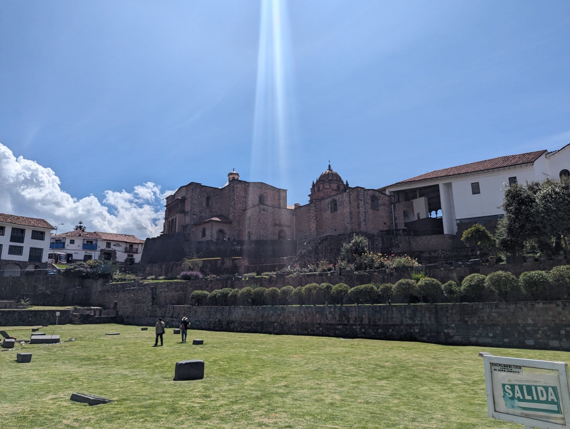
The temple and church seen across the lawn below them, May 2024.
The Punchao. A second and better-attested Sun image was the Punchao, "day." Juan de Betanzos describes it as the size of a one-year-old child.26 When Spanish troops took the last Inca stronghold at Vilcabamba in 1572, they captured it along with the young ruler Túpac Amaru. Viceroy Francisco de Toledo described it that year as cast gold, hollow, holding powder made from the hearts of earlier rulers, and ringed with small gold plates that dazzled anyone looking at it.26 The historian Catherine Julien argued that Toledo carried it to Spain in 1581, and that a gold idol taken from his estate after his death may be the Punchao, kept in the royal treasure house in Madrid into the early 1600s.29 After that it disappears. Garcilaso's Sun image, wide enough to fill a wall, seems to be a different object. He says it fell to the conquistador Mancio Serra de Leguizamo, who lost it at cards in a single night.25
Ruin and rebuilding. The stripping began in 1533, when three Spaniards came to Cusco to collect gold for Atahualpa's ransom. Pedro Sancho, Pizarro's secretary, recorded "five hundred-odd plates of gold torn from some house-walls in Cuzco," the smallest weighing four or five pounds. They also brought a gold seat and a gold fountain.20 The figure of 700 plates, common in modern accounts, comes from later retellings.3028 The building stayed standing: in 1537 the Almagro faction used it as a prison for two of the Pizarro brothers.26
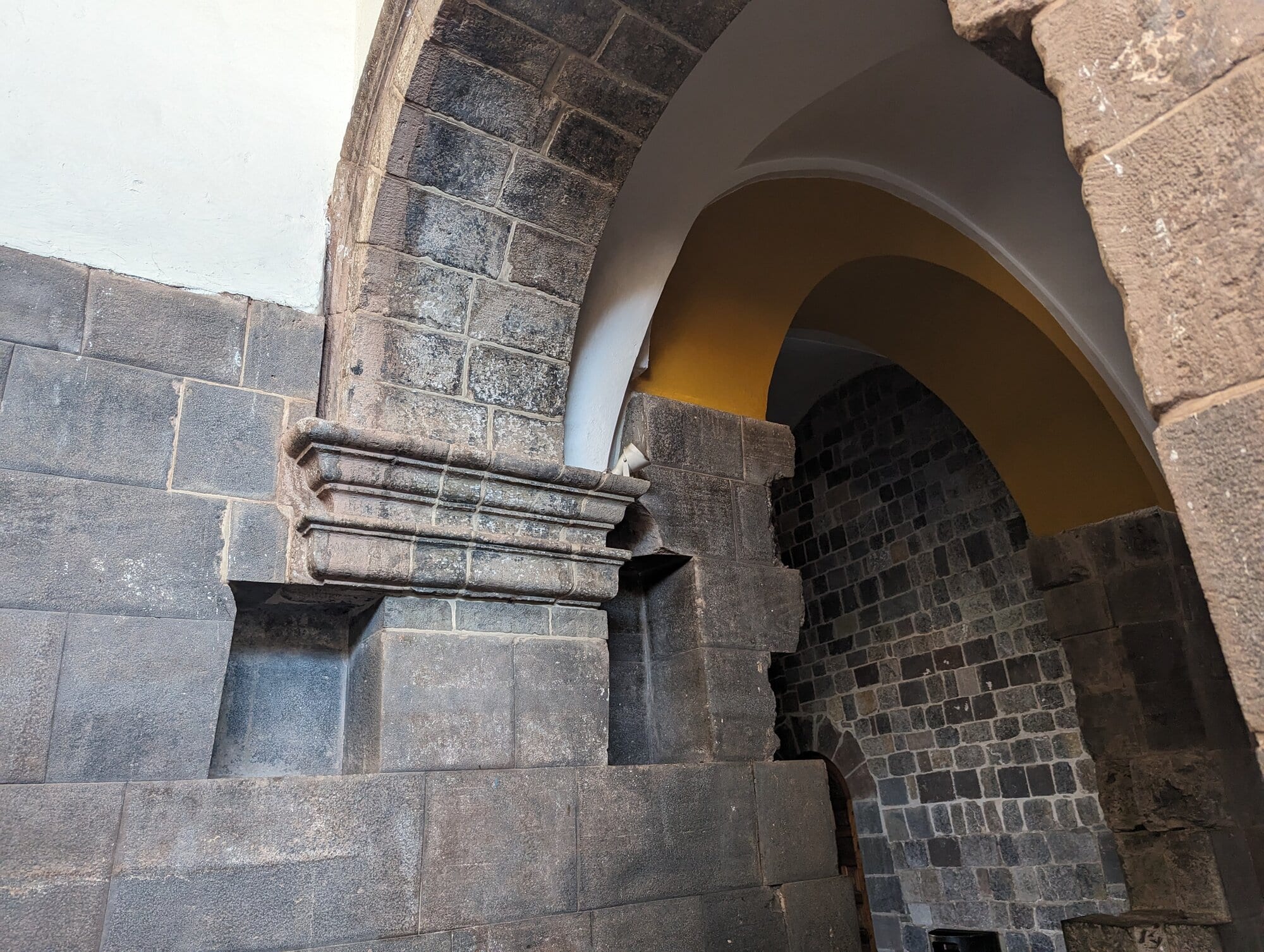
A colonial arch built onto Inca masonry inside the convent, May 2024.
- Fitted Inca stonework
- The colonial arch above it
Francisco Pizarro's brother Juan received the temple and handed it to the Dominican order. Sources disagree on the date. Smarthistory gives 1534.22 The Dominicans' own history gives 1538.23 Juan Pizarro died in 1536, which makes the later date hard to fit.31 The friars built their church on the Inca walls and consecrated it in 1633. The earthquake of 1650 brought much of it down, and it was rebuilt.2319
The earthquake of 21 May 1950 collapsed the bell tower and cracked the apse. It also exposed Inca masonry that the convent had hidden for four centuries.235 A UNESCO mission led by George Kubler came in June 1951 to advise on repairs. One of its members was the Peruvian architect Oscar Ladrón de Guevara.5 He then directed the restoration of the Qorikancha and Santo Domingo for years, and his plans are dated 1960 and 1963.26 Colonial walls that covered Inca rooms were removed. Missing parts of the Inca walls were rebuilt by reassembling original stones, a method called anastylosis. The tower was rebuilt around a hidden concrete core, and the main work ended in 1976.262332 Photographs of one niche from the 1940s, set beside its present state, show how much was put back.26
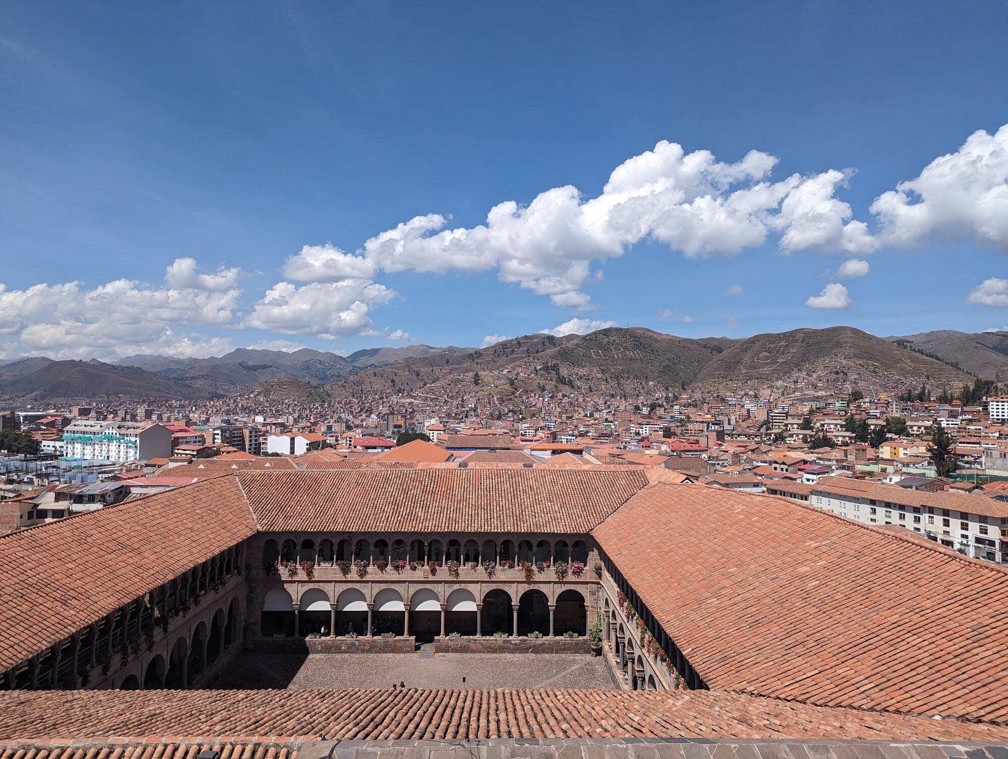
The cloister of Santo Domingo from above, with Cusco beyond, May 2024.
Digging has continued in the garden below the church. A 1981 photograph shows excavations there.33 A small underground site museum now sits beneath the lawn. Guidebooks say its objects come from excavations in the early 1990s.34
Where it stands. The general layout is genuine. So are the curved wall and long stretches of the enclosure and room walls. The rest is a mix of Inca stone, colonial building and twentieth-century reconstruction, and in places the joins are hard to see.26 The gold is gone, and its descriptions rest on a handful of Spanish writers. The room names come from Garcilaso, writing from memory in Spain. The Punchao, the one sacred object traced past the conquest, was last recorded in Madrid.
The ceque system
The fullest description of the ceques comes from the Jesuit Bernabé Cobo, writing in 1653, who lists the shrines line by line.3 The lines ran outward from the Qorikancha. Each of three suyus had nine lines and the fourth, Kuntisuyu, had 14 or 15, for 41 or 42 in all.8 Each line held a set of huacas, from three to more than a dozen, and each was cared for by a particular kin group.8 Some huacas marked boundaries, some marked places where events had happened, and some had meaning for the calendar or the sky. Worshippers walked each line to make offerings at its shrines.4
The Dutch anthropologist R. Tom Zuidema made the ceques famous with his 1964 book The Ceque System of Cuzco, which treated them as a map of the social organization of the capital.35 He later proposed that the 328 huacas might stand for days in a calendar. 328 is close to the length of twelve sidereal months, the time the Moon takes to circle the sky twelve times, and Zuidema suggested some lines served as sight lines for astronomy.8
From 1990 to 1995 Bauer led a field project to find the huacas on the ground.3 His survey, published in 1998 as The Sacred Landscape of the Inca, combined fieldwork with archival research on Cusco's kin groups and their lands.3 The lines turned out to be far from straight. They curve and zigzag, bend to reach the shrines, and often track springs and canals that marked irrigation districts.8 On this reading the ceques are first a map of who held which land and water, and who owed which rituals.
Deep Dive: The ceques: the list, the theories, the ground
Everything known about the ceques passes through one document. Cobo's 1653 list of the shrines was copied from an older manuscript that no longer survives.36 Cobo built most of his account of the Inca from earlier writers, often without naming them, and the four chapters on the shrines of Cusco read like one such borrowed block.37 The translator Roland Hamilton found Cobo's own handwritten manuscript in Seville in 1974. Rowe, working from it, judged that the odd spellings of shrine names came from Cobo's source, a poor copy by someone who knew little Quechua.37 Hamilton later translated the religious books of Cobo's history into English as Inca Religion and Customs (1990), the version most English readers use.38
Who wrote the lost original is disputed. Zuidema credits a text of 1561 by the jurist Juan Polo de Ondegardo, or written at his instigation, and argues that Polo translated what Inca specialists read off the cords of their quipus, the knotted-string records of the Inca state.39 In his 1964 book he had suggested a different author, the priest Cristóbal de Molina.40 The archaeologist John Rowe, who had once proposed Molina himself, rejected both names in 1981. The list mentions the parish "of the Martyrs," which existed only between 1559 and 1572, so it was written in those years. Polo said he had found more than 400 shrines and had drawn up a chart of them, while the list is a written narrative with about 332 entries. Polo also wrote in 1571 that he had never found the Creator's temple in Cusco, and the list gives its location.37 Bauer, following Rowe, also sets the Polo attribution aside and writes that the author and date of the original manuscript have not been clearly identified.36
The list is organized in three steps. It names a suyu, or quarter, then each ceque in that quarter, then each huaca on the ceque in order, from the one nearest the Qorikancha to the farthest.37 Rowe gave every shrine a short code: the first two letters of the quarter, the line number and the shrine number. Ch-1:2 is the second huaca on the first line of Chinchaysuyu, and Cu-13:3 the third on the thirteenth line of Kuntisuyu. Bauer and most later writers use these codes, and Bauer's book prints a table setting them beside Zuidema's older scheme, which labeled the quarters I to IV and each line by group and rank.3741 Rowe also noted that this kind of ordered list is well suited to a quipu, a point on which he and Zuidema agreed.37
Rowe showed that the list is incomplete. A partial list of Chinchaysuyu shrines by another priest, Cristóbal de Albornoz, has 12 of its 35 shrines missing from Cobo. Some lines begin far out in the valley, so their first shrines near the temple were probably lost. Two shrines have no names, and at the end four Chinchaysuyu shrines are added because they had not been recorded on their lines.37 The familiar total of 328 is therefore a count of a damaged record, and the number of lines, 41 or 42, also depends on how the sources are read.48
The shrines range from the small to the very great. Many were springs, boulders, caves and canals.8 Michosamaro (Ch-1:1) was a stone said to be a companion of the first Inca, Manco Capac, who was killed by one of the women of their party and turned to stone. Guaracince (Ch-2:1), in the temple square, was where earthquakes were thought to form. Racramirpay (Ch-2:2) was a stone set in a window, said to be a warrior who appeared in the air to help Inca Yupanqui, the ruler later called Pachacuti, win a battle. Fourteen entries are pururaucas, stones that the Inca said had risen as soldiers to fight the Chanca, a rival people who attacked Cusco. Three shrines on the ninth Chinchaysuyu line mark places in that war, and Cusicancha (Ch-5:1) was the house where Inca Yupanqui was born.37
Royal places were shrines too. Aucaypata (Ch-5:4), the main square, received the "universal sacrifice" for the Sun and the other huacas. Sabacurinca (Ch-5:6) was a finely carved seat where the Incas sat, and through it the whole fortress of Sacsayhuamán was worshiped. Tambomachay (An-1:9) was a house where Inca Yupanqui lodged when hunting, flanked on its line by two springs.37 An-5:1 was a stone called usno in the lower part of the plaza, the first huaca to which young nobles made offerings at their coming of age. An ushnu was a ritual platform or pillar used for drinking to the Sun, and Rowe notes that the great ushnu of the main plaza is itself missing from the list.37
At the other end of the scale stands Huanacauri (Co-6:7), a mountain of 4,089 meters southeast of the city and one of the most important huacas of the Inca. The chronicler Guaman Poma, drawing around 1615, set its name beside Inti, the Sun, among the "idols" of the Inca.42 Cobo's list calls it the oldest shrine of the Inca after the cave of origin at Pacaritambo, where one of the first Inca's brothers turned to stone. The Spaniards took its gold but ignored the plain stone, which the Inca hid and kept.37
The first big theory was social. Zuidema's The Ceque System of Cuzco (1964) treated the list as a map of the social organization of the capital.35 The four quarters fell into two moieties, or halves of the community: Hanan (upper) Cusco held Chinchaysuyu and Antisuyu, and Hurin (lower) Cusco held Collasuyu and Kuntisuyu.408 In each quarter the lines came in groups of three, ranked as collana, payan and cayao. Collana means "first" or "most prominent"; payan and cayao were the middle and lowest ranks.4043 The list says which kin group served each line. Some were panacas, the descent groups of past rulers, formed by each king's descendants except the heir; others were ayllus, the ordinary Andean kin and land-holding groups.40 Zuidema read the pattern of ranks and groups as a model of Inca kinship and politics. He also argued that the line a group served did not show where it lived.40 Zuidema returned to the theme in Inca Civilization in Cuzco (1990), which covers the valley's districts, irrigation, age classes and calendar.44
The second theory was about time and the sky. Zuidema proposed that the 328 huacas stood for the days of a ritual year.8 328 is twelve sidereal months of 27⅓ days, the time the Moon takes to return to the same place among the stars, as opposed to the synodic month of about 29½ days from one full moon to the next. He counts eight days on average per line (41 × 8 = 328) and the remaining 37 days of the solar year as a period outside the count.39 He and others link those 37 days to the time when the Pleiades, a star cluster closely watched in the Andes, are hidden in the Sun's glare.45 With the astronomer Anthony Aveni he measured horizon alignments around Cusco in 1976 and 1980. They argued that some lines ran straight to points on the horizon and worked as sight lines from the Qorikancha.4647 The list itself gives support for a few cases. Sucanca (Ch-8:7) was a hill with two markers, and when the Sun reached them it was time to plant maize. Chinchincalla (Cu-13:3) had two more.37 Catachillay (Ch-8:10), a spring on the same line as Sucanca, has a name also used for the Pleiades.47
Bauer and the astronomer David Dearborn, in Astronomy and Empire in the Ancient Andes (1995), reached conclusions that differ in several points from Zuidema's and from Aveni's.48 They accept that the Inca watched the Sun and took a real interest in the Pleiades. They found less evidence for sight lines along the ceques and argued that the shrines on many lines stray too far from a straight path to guide the eye. They also noted that the Pleiades vanish for 40 to 50 days in practice, which loosens the link to 37.47 Zuidema reviewed the book critically in 1996.49 Zuidema had argued that a ceque could be a sight line with its huacas lying a little to either side, and the list does say one spring (Ch-9:4) stood "somewhat apart" from its line.4737 In a 2010 book he wrote that astronomical observation "did not depend on the directions of the ceques."46 A Polish team's 3D scan of the Qorikancha, published in 2018, found that a corridor Zuidema and Aveni used points about 22 minutes of arc away from their figure. The interval it marks becomes 57 or 58 days instead of the 55 that his calendar needed.46
A third reading came from water. The anthropologist Jeanette Sherbondy went to Cusco in 1975 to study irrigation. She mapped a canal that starts at Tambomachay and runs past the village of Yuncaypata, whose people may not touch a drop, to fields at San Sebastián held by descendants of two royal panacas. She then noticed that Tambomachay sits on the collana line of Antisuyu, served by one of those same panacas.43 Matching her canal map to the list, she argued that the ceques recorded who held which canals and fields. A line served by a kin group included the spring that fed its canal, and neighboring lines marked the edges of its irrigation district. The canals of Chacán, for example, were held by Iñaca panaca, whose line ran through their source, while two other lines marked the district's east and west edges.43 In Andean thought the right to worship a spring went with the right to its water. Sherbondy concluded that the system was a register of water and land titles, which is why the lines are unevenly spaced.43 She also counted about a third of all the huacas as water sources.50 Her work was a direct challenge to Zuidema's view that lines and residence were unrelated, though she saw it as confirming other parts of his model.43
The fourth test was the ground itself. From 1990 to 1995 Bauer led a field project to find the huacas.3 His aim, in a 1993 grant summary, was to use archives in Peru and Spain and then field survey to place the shrines in real space, since "many remain unknown."51 In his first report on the fieldwork, Bauer identified likely locations for 85 shrines and probable routes for nine ceques in Collasuyu, the southeast quarter of the valley.52 He found internal inconsistencies, and possibly errors, in the list, and concluded that the routes varied far more than the models allowed.52 The Sacred Landscape of the Inca (1998) works through all four quarters, with Rowe's English translation of the list and an index of shrine names by Margot Beyersdorff.4153 The pattern that came out of the survey is that the shrines set the course of each line, not the other way round. In Bauer's words, "it is the specific locations of the huacas that define the course of the lines and not vice versa."47 The lines bend to reach them and generally do not cross one another, and four of them follow the four main Inca roads out of the city.8
The four readings do not cancel out. The ceques plainly carried social meaning, since each line belonged to a kin group.8 Some huacas plainly had calendar meaning, and the list itself names the planting markers.437 Sherbondy's link between lines and water rights rests on her canal maps, and the survey bears out that many lines track springs and canals.8 What remains open is how far the whole system was designed as a calendar, or as a set of straight sight lines, and whether a damaged colonial copy can carry a count as exact as 328.3746 Worshippers walked each line to make offerings, sometimes on Inca roads and sometimes straight across country.4 That ritual use of the lines is the one point every reading shares.
Key books:
- Bernabé Cobo, Inca Religion and Customs, translated by Roland Hamilton, 1990. The English text of the shrine list and Cobo's account of Inca religion.38
- R. Tom Zuidema, The Ceque System of Cuzco, 1964. The founding structural study of the lines, ranks and kin groups.35
- R. Tom Zuidema, Inca Civilization in Cuzco, 1990. His later synthesis, including the 328-day calendar.44
- Brian S. Bauer and David S. P. Dearborn, Astronomy and Empire in the Ancient Andes, 1995. The main critique of the ceque sight-line and calendar arguments.48
- Brian S. Bauer, The Sacred Landscape of the Inca, 1998. The field survey of the shrines, with Rowe's translation of the list.3
- Brian S. Bauer, Ancient Cuzco: Heartland of the Inca, 2004. The valley's archaeology from the first hunters to 1532, with a section on the Qorikancha and the ceque shrines.54
- Terence N. D'Altroy, The Incas, 2nd edition, 2014. A general history of the empire that sets the ceques among Inca religion and politics.55
- John H. Rowe, "Una relación de los adoratorios del antiguo Cuzco," 1981. The Spanish text of the list with Rowe's codes and his case on its date and author.37
- Jeanette E. Sherbondy, "Los ceques: código de canales en el Cusco incaico," 1986. The water reading in article form.43
The Inca also watched the sun set behind pillars on the hills.
Sacsayhuamán
Sacsayhuamán stands on the hill north of the city at about 3,700 meters.30 Its best-known part is a great plaza with three massive terrace walls built in zigzags. The longest wall runs about 400 meters, and some blocks weigh well over 100 tonnes.30 The Spanish called it a fortress. Cieza de León, who saw it twice, says the people called it the House of the Sun.30
Sarmiento says Tupac Inca built it as the head of the puma, with workers drawn from every province: some brought stones, some worked them, some laid them.9 Cieza says it was begun under Pachacuti and continued by Tupac Inca, Huayna Capac and Huascar, and that the Inca asked the provinces for 20,000 workers who served in rotation.30 Cieza also reports a huge stone near the fortress that, the people said, "got tired" on the way and could not be moved further.30 For Dean, stories like this are a sign that the Inca treated stones as beings with their own will.7
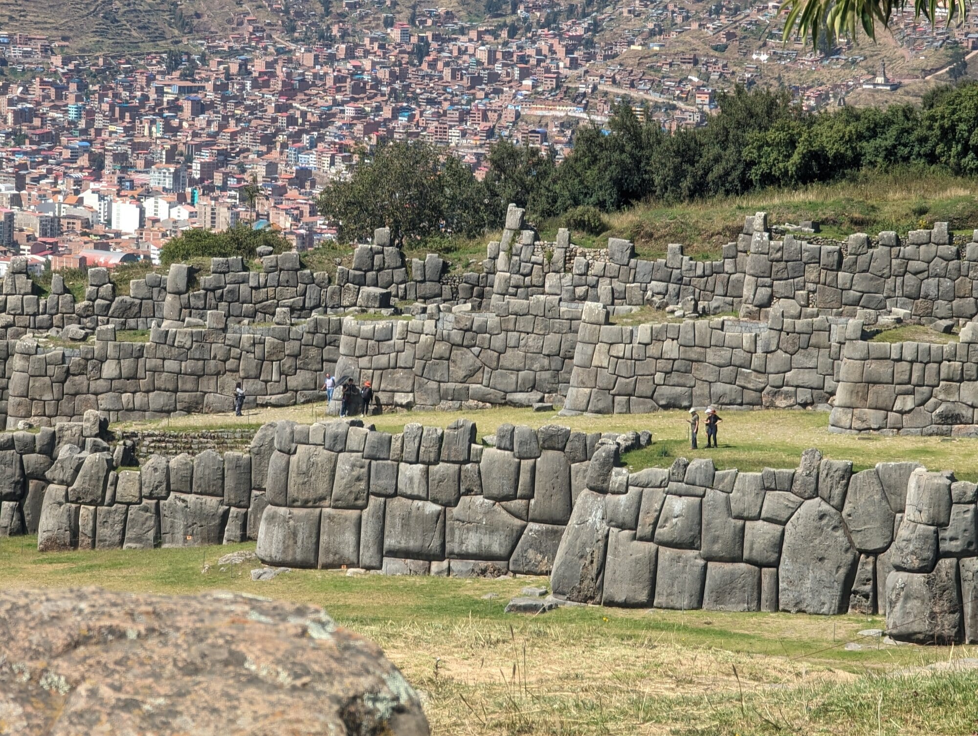
Sacsayhuamán's terrace walls, with Cusco spreading over the hills behind, May 2024.
- The lowest wall, built of huge fitted blocks
- The next terrace wall up
- Cusco on the hillsides beyond
In 1536 the Inca ruler Manco Inca laid siege to the Spanish in Cusco. The siege lasted about ten months and failed, and Manco withdrew to Vilcabamba.2 After the conquest the Spanish used Sacsayhuamán as a quarry. Sarmiento says it stood intact until the wars between Pizarro and Almagro, after which the Spanish began to pull it down to build their houses.9 Garcilaso de la Vega wrote that "there is indeed not a house in the city" built by the Spaniards that was not made of its stone.30 What remains are mostly the blocks too large to move.30
Colonial writers also described passages running under the hill, and one of them is now being dug.
Deep Dive: The tunnel under Cusco
For centuries the story ran that a tunnel, a chinkana, linked the Qorikancha to Sacsayhuamán. An anonymous Jesuit account of 1594 describes a main passage from the temple, under the bishop's house behind the cathedral, to the fortress about a mile away.57 Garcilaso de la Vega and Martín de Murúa describe similar passages.58 According to the archaeologists now working on it, the entrances were sealed in the early 1840s on the orders of the prefect Miguel de San Román, after accidents underground.5958
In January 2025 the Peruvian archaeologists Jorge Calero Flores and Mildred Fernández Palomino, of the Chinkana-Sacsayhuamán Project, announced the results of a survey with ground-penetrating radar and acoustic prospecting, guided by the colonial accounts. They reported a main tunnel more than 1,750 meters long and up to 2.5 meters deep, running from the Qorikancha toward Sacsayhuamán, with three branches toward Callispuquio, the church of San Cristóbal and the Muyucmarca sector of the fortress.6057
Excavation began on 27 May 2025 under a permit from Peru's Ministry of Culture, at what the team takes to be the original entrance on the Sacsayhuamán side.61 After 45 days and five excavation units, the team reported radar evidence of cavities up to 2 meters high, and a crack it believes leads to another section.59 By 2026 it reported walls and carved stone corridors, five passages linking the two sites, and possible galleries 4 to 9 meters underground, with deeper cavities on the radar.58 The team has also spoken of a network of about 8 kilometers.59 Calero Flores has said that confirming the network's extent "is not easy," because the passages are deep and hard to detect.58
Where it stands, as of 2026: the tunnel has moved from legend to active archaeology. Excavation has found built underground structures at Sacsayhuamán, and the radar shows voids along the line the colonial accounts describe. The full route to the Qorikancha rests so far on geophysics and documents rather than on a passage anyone has walked. No peer-reviewed report has appeared yet, and the published accounts come from the team itself, so the larger figures should be read as the team's working claims.5861
Stone and earthquakes
Most Inca buildings were made of fieldstone or rough blocks set in clay mortar, or of adobe on stone footings. The famous dry, close-fitted masonry was reserved for high-status buildings such as palaces and temples. Rowe sorted it into two kinds: coursed masonry, with squared blocks in rows, and polygonal masonry, with many-sided blocks fitted like a puzzle.21
The architect Jean-Pierre Protzen tested how this was done. He found that the stones were taken from rockfalls or pried from rock faces, split with large hammerstones and shaped with smaller ones. Each new stone was fitted by cutting into the stones already laid, by trial and error. His conclusion was that the work could be done "with little effort and in a short time."62
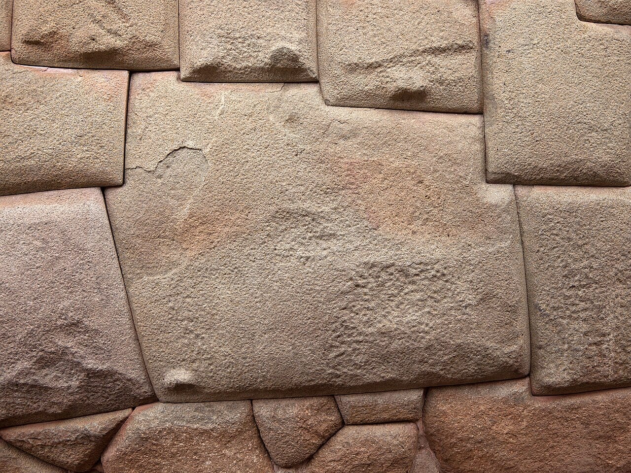
The twelve-angled stone in the wall of Hatun Rumiyoc street, 2013. Photo: Unukorno, CC BY 3.0, via Wikimedia Commons.
- The twelve-angled stone
- A step in its top edge; the block above sits down into it
- Small stones cut to fit its lower edge
The most famous polygonal block is the twelve-angled stone on Hatun Rumiyoc street, whose twelve corners lock it against eleven neighbors. The wall dates to the reign of Inca Roca, whom tradition places around 1350 to 1380, and once enclosed his palace. The Spanish partly demolished the palace and rebuilt it as the archbishop's residence. In February 2025 a man chipped the stone with what may have been a hammer, and Cusco's culture director called the damage "irreversible."63
Inca walls usually lean slightly inward, have rounded corners, and use trapezoidal doors and niches. These features are often credited with helping them ride out earthquakes.21 The 1950 quake gave a test. On 21 May, within six seconds, some 300 people were killed or injured and 3,000 homes destroyed, with heavy damage to churches.5 Spanish buildings suffered more than Inca ones.2 UNESCO sent a mission led by George Kubler of Yale in 1951, and by 1956 Kubler could report that nearly three-quarters of the monuments had been rebuilt in five years.5
The Inca walls are not quake-proof, though. A 2022 survey of nine Inca sites near Cusco recorded almost 3,000 signs of earthquake damage in the stonework. It found two strong ancient quakes in the record: the one of 1650, and one in Inca times, about 1400 to 1533, that no written source mentions.64 For Inca buildings, the 1950 quake turned out less damaging than had been thought.65 The 1650 quake struck on 31 March. During it a crucifix from the cathedral was carried into the square, and as the Señor de los Temblores, the Lord of the Earthquakes, it is still carried in procession every year.662
Deep Dive: Myths about Inca stone
Some popular claims about Inca masonry are true in part, and some are folklore.
- "No mortar." True for the fine masonry of temples and palaces. Most Inca walls used clay mortar.21 One early Spanish account even speaks of "a sort of bitumen" in the Qorikancha's walls, though the stones fit so well that no joint could be seen.19
- "You cannot fit a knife blade between the stones." Spanish writers said much the same: Cieza that a coin could not be put between two stones, Pedro Pizarro that the point of a pin could not.30 It holds for the best walls and not for the many rougher ones.
- "The Inca melted or softened stone." There is a local story that Inca masons, like a small bird, could soften rock with a plant's juice, and a few writers have proposed an acid etching method.21 Neither has been shown. Protzen's experiments show that hammerstones and patient fitting are enough.62
- "Someone older built the giant walls." The colonial writers record the Inca and their labor levies building Sacsayhuamán.930 There may be Killke work on the hill,15 but the great zigzag walls are attributed to the Inca.
- "The walls are earthquake-proof." They have survived better than colonial buildings, but they also carry the scars of at least two strong quakes.64
Dean also looks at how the Spanish and, later, the tourism industry laid their own meanings onto Inca stone.7
Inti Raymi and living tradition
Inti Raymi, the "festival of the Sun," was the great Inca ceremony for Inti at the June solstice, the shortest day of the southern year and the Inca new year. According to Garcilaso it was set up by Pachacuti and held in the main square of Cusco.67 After 1535 the Spanish authorities and the Church banned it with other Inca religious rites.67
The modern Inti Raymi dates from 1944. A group of Cusco intellectuals led by the historian Humberto Vidal Unda proposed a festival for the city in 1943. In January 1944 the authorities set 24 June as the Day of Cusco and agreed to revive Inti Raymi. The first staging, at Sacsayhuamán on 24 June 1944, was written by the Quechua scholar Faustino Espinoza Navarro, who also played Pachacutec.68 It drew mainly on Garcilaso's account.67 Today some 750 to 800 actors take part, and the performance moves from the Qorikancha to the Plaza de Armas and on to Sacsayhuamán. Peru declared it part of the national cultural heritage in 2001.68 The date, 24 June, falls a few days after the solstice, on the Catholic feast of Saint John the Baptist.67
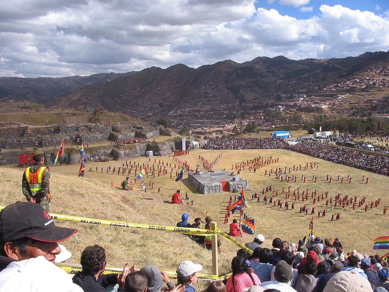
Inti Raymi on the esplanade at Sacsayhuamán, 24 June 2007. Photo: Mme Berthe, CC BY-SA 3.0, via Wikimedia Commons.
- The stone platform built as the stage for the ceremony
- Sacsayhuamán's terrace walls
- Spectators along the edge of the esplanade
- Cusco, in the valley below
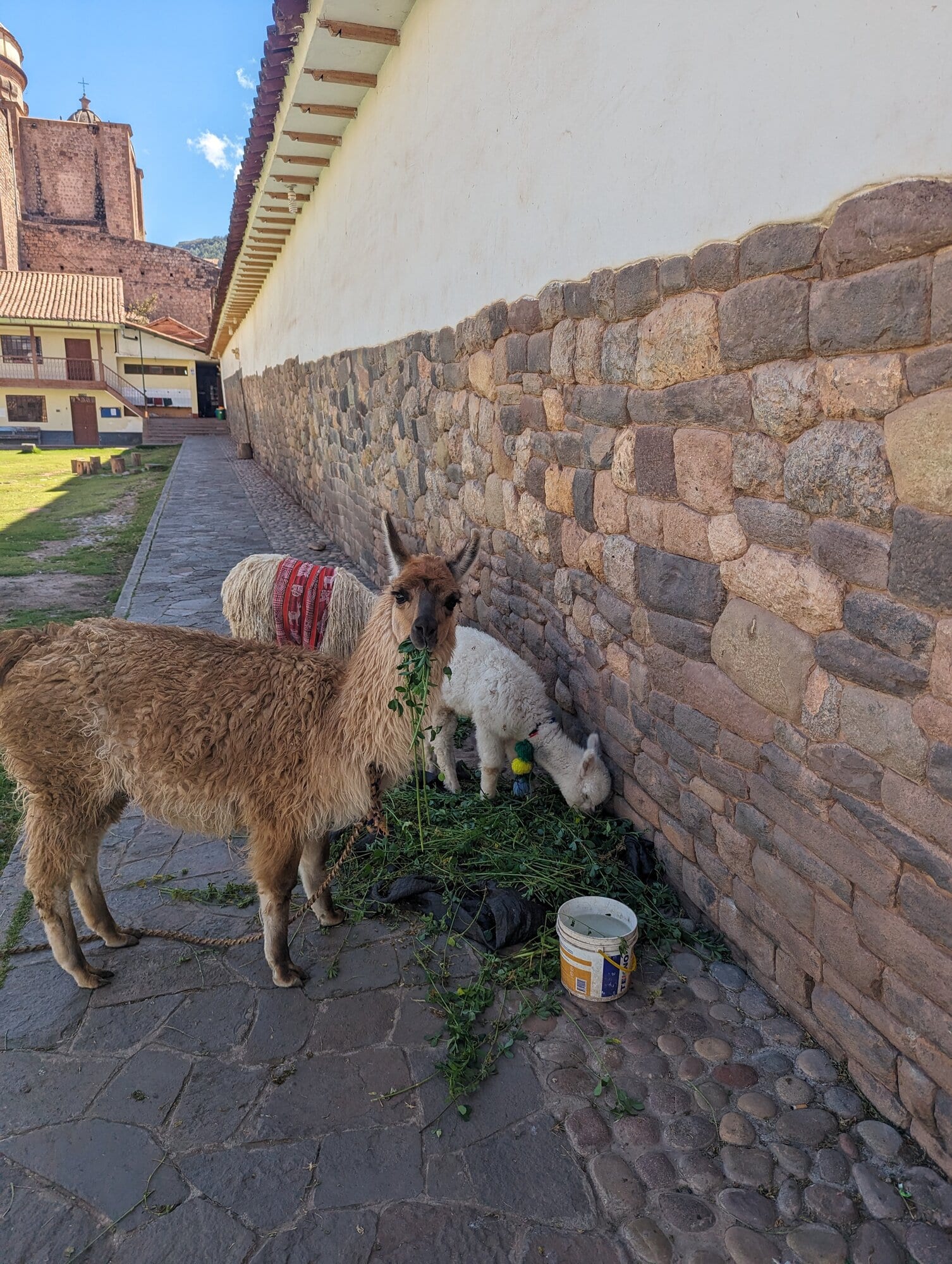
Llamas fed beside an Inca wall in the old city, May 2024.
Inti Raymi is a 20th-century reconstruction, and that is part of its history. Other traditions run in an unbroken line from the colonial period. In the colonial Corpus Christi festival, Andean nobles took part dressed as the Inca kings. Dean argues they used the feast to build new identities joining Andean and Christian worlds, and she traces those identities into Cusco's festivals today.69 Quechua is still the everyday language of much of the region: in the 2017 census, 55.2 percent of people in the Cusco region said they learned an Indigenous language as children.6 Espinoza Navarro also co-translated the city's anthem into Quechua in 1991.2 Weaving is another living thread. The Center for Traditional Textiles of Cusco was founded in 1996 by the weaver Nilda Callañaupa and the weavers of Chinchero, and works with ten weaving communities.70
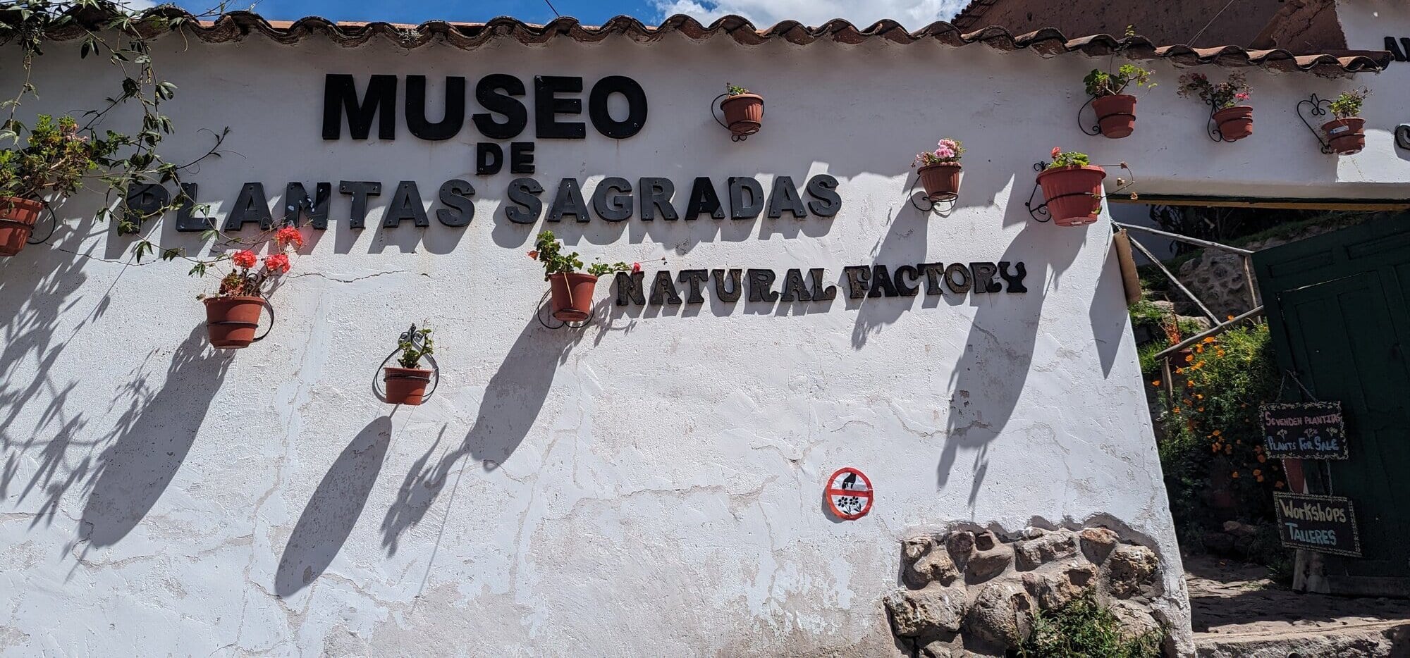
A museum of sacred plants in Cusco, May 2024.
Plants are part of the living tradition too. For the Inca, coca was the most valued of prestige goods. Access was at first limited to the elite, priests read its leaves for divination, and it was burned as an offering to the Sun and the other gods. Andean people still chew the leaves or brew them as tea, against altitude sickness, pain and hunger.71 The San Pedro cactus, which contains mescaline, has a much older ritual history in northern Peru, with archaeological evidence going back to the Chavín culture around 1000 BCE, and it is still used in night-long healing ceremonies there.72
Every year tens of thousands walk up to a glacier sanctuary east of Cusco.
Footnotes
-
UNESCO World Heritage Centre, "City of Cuzco," World Heritage List no. 273, inscribed 1983 (read in full from an archived copy, since the live page blocked automated access; altitude, Pachacutec, 3,000 years, criteria, earthquakes). whc.unesco.org ↩ ↩2 ↩3 ↩4 ↩5 ↩6
-
Wikipedia, "Cusco" (secondary source; Quechua name, Spanish arrival 15 November 1533, the 1536 siege, slower growth before Pachacuti, the 1650 and 1950 earthquakes, the Señor de los Temblores procession, the anthem in Quechua). en.wikipedia.org ↩ ↩2 ↩3 ↩4 ↩5 ↩6 ↩7 ↩8
-
University of Texas Press, book page for Brian S. Bauer, The Sacred Landscape of the Inca: The Cusco Ceque System, 1998 (publisher description: 328 huacas on 42 ceques from the Coricancha; Bauer's 1990 to 1995 project; Cobo's list in the appendix, per a library abstract). utpress.utexas.edu ↩ ↩2 ↩3 ↩4 ↩5 ↩6
-
Dumbarton Oaks, "Pathways," in the online exhibit Standing on Ceremony: Processions, Pathways, and Plazas (huacas, 41 or 42 ceques, at least 328 huacas, processions along each line). doaks.org ↩ ↩2 ↩3 ↩4 ↩5 ↩6 ↩7
-
"Celebration in Cuzco: Old Inca capital restores its 'quake-torn monuments," The UNESCO Courier, June 1958, pp. 4-11 (read in full; the 21 May 1950 quake, the Kubler mission of June 1951, Kubler's 1956 report, the 1650 quake). unesco.org ↩ ↩2 ↩3 ↩4 ↩5
-
RPP, "Ministerio de Cultura: Lima es el departamento con mayor población que se autoidentifica como indígena," reporting the Ministry of Culture's analysis of the 2017 census (Cusco 55.2 percent; read via search summary, the share for Quechua alone not given). rpp.pe ↩ ↩2
-
Duke University Press, book page for Carolyn Dean, A Culture of Stone: Inka Perspectives on Rock, 2010 (description and endorsements only; the book itself not read). dukeupress.edu ↩ ↩2 ↩3
-
Wikipedia, "Ceque system" (secondary source; suyus, Hanan and Hurin, lines per suyu, kin groups, line shapes, Zuidema's calendar idea; cites Bauer 1992 and D'Altroy 2003). en.wikipedia.org ↩ ↩2 ↩3 ↩4 ↩5 ↩6 ↩7 ↩8 ↩9 ↩10 ↩11 ↩12 ↩13
-
Pedro Sarmiento de Gamboa, History of the Incas (1572), translated by Clements Markham, Hakluyt Society, 1907, chapters XXXI and LIII with Markham's note 112 on Pumap chupan, and his introduction (read in the Project Gutenberg text). gutenberg.org ↩ ↩2 ↩3 ↩4 ↩5 ↩6 ↩7 ↩8 ↩9 ↩10
-
Richard L. Burger, Lucy C. Salazar, Jason Nesbitt, Eden Washburn and Lars Fehren-Schmitz, "New AMS dates for Machu Picchu: results and implications," Antiquity, 2021 (abstract only: occupation about AD 1420 to 1532, about two decades before 1438). cambridge.org ↩
-
UBC Press, book page for Brian S. Bauer, Ancient Cuzco: Heartland of the Inca, University of Texas Press, 2004 (description and table of contents only, including the chapter "The Development of the Inca State (AD 1000-1400)" by Bauer and R. Alan Covey). ubcpress.ca ↩ ↩2
-
Wikipedia, "Pikillaqta" (secondary source; Wari site in the Lucre Basin, occupied about AD 550 to 1100). The standard monograph is Gordon F. McEwan, ed., Pikillacta: The Wari Empire in Cuzco, 2005 (not read). en.wikipedia.org ↩
-
Wikipedia, "Killke culture" (secondary source; 900 to 1200 AD, Rowe's pottery description, Oscar Rodriguez on early work at Sacsayhuamán). en.wikipedia.org ↩ ↩2
-
Brian S. Bauer and R. Alan Covey, "Processes of State Formation in the Inca Heartland (Cuzco, Peru)," American Anthropologist 104, 2002, 846-864 (citation confirmed; not read). anthrosource.onlinelibrary.wiley.com ↩
-
Associated Press, "Ancient temple unearthed near Inca capital," via NBC News, 14 March 2008 (Oscar Rodriguez, Washington Camacho, Luis Lumbreras). nbcnews.com ↩ ↩2
-
Archaeological Institute of America, "Cuzco," Archaeology magazine online feature, 1 September 1999 (the puma plan, Pachacuti's rebuilding, the 1950 quake exposing the Coricancha's walls). archaeology.org ↩ ↩2 ↩3
-
Ministerio de Cultura del Perú, "Plaza Inca Hanan Hawkaypata," 3D model record with description, Zenodo, 2020 (Rowe's puma reading, Chávez Ballón's suggestion, Betanzos and Sarmiento; it gives both 1967 and 1968 for Rowe, whose article is "What Kind of a Settlement Was Inca Cuzco?" Ñawpa Pacha 5, not read). zenodo.org ↩ ↩2
-
Giulio Magli, "On the astronomical content of the sacred landscape of Cusco in Inka times," arXiv physics/0408037, 2004 (read via search summary; the puma as "a long-standing tradition"). arxiv.org ↩ ↩2
-
Wikipedia, "Coricancha" (secondary source; names, gold, ransom, mummies, the quoted early account of the walls, Santo Domingo after 1650, four surviving rooms, Krupp's quote). en.wikipedia.org ↩ ↩2 ↩3 ↩4 ↩5 ↩6 ↩7 ↩8 ↩9
-
Pedro Sancho, An Account of the Conquest of Peru (1534), translated by Philip Ainsworth Means, Cortes Society, 1917, chapter I (the passage on the gold from Cuzco read in the Project Gutenberg text). gutenberg.org ↩ ↩2
-
Wikipedia, "Inca architecture" (secondary source; fieldstone and mortar, Rowe's classification, ashlar for sacred buildings, curved walls, inward lean, the stone-softening folklore and etching hypothesis). en.wikipedia.org ↩ ↩2 ↩3 ↩4 ↩5 ↩6
-
Smarthistory, "Introduction to religious art and architecture in early colonial Peru" (read via search summary; the site blocked automated access; founding in 1534, four Inka rooms). smarthistory.org ↩ ↩2 ↩3
-
Wikipedia, "Church and Convent of Santo Domingo, Cusco" (secondary source; Juan Pizarro and 1538 from the Dominican province's website, consecration in 1633, 1950 damage from Kubler's report, Ladrón de Guevara and 1976 from the Cusco municipality's heritage record, the tower's concrete core, the apse on the Inca "torreón"). en.wikipedia.org ↩ ↩2 ↩3 ↩4 ↩5
-
Pedro de Cieza de León, The Second Part of the Chronicle of Peru, translated by Clements R. Markham, Hakluyt Society, 1883, chapter XXVII, pp. 83-86 (read in full in the archive.org scan; the enclosure, gold band, four houses, the Sun's figure, the gold maize garden and llamas, Villac Umu; Cieza says he wrote what he saw and what he heard from the first Spaniards to reach Cusco). archive.org ↩ ↩2 ↩3
-
Garcilaso de la Vega, First Part of the Royal Commentaries of the Yncas, vol. 1, translated by Clements R. Markham, Hakluyt Society, 1869, Book 3, chapters XX to XXIV, about pp. 270-284 (read in full in the archive.org scan; the Sun image and Mancio Serra, mummies and Polo's 1559 find, five halls, Villac Umu, porches, five fountains and the 1558 flood, the gold garden, "Ccuricancha" as "court of gold"). archive.org ↩ ↩2 ↩3 ↩4 ↩5 ↩6
-
Mariusz Ziółkowski and Jacek Kościuk, "Astronomical observations in the Inca Temple of Coricancha (Cusco)? A critical review of the hypothesis," Teka Komisji Architektury, Urbanistyki i Studiów Krajobrazowych 14(1), 2018, 7-33 (read in full; the curved "balcony" wall, Farrington's nine buildings, R-1 to R-4 and R-A to R-E, the "so-called" Enclosure of the Stars, the 1537 prison, Ladrón de Guevara's 1960 plan, 1963 drawings and the 1960 lintel find, the 1942 and present photos, Toledo's 1572 letter on the Punchao and Betanzos on its size, both quoted from the paper, and the 2011-2014 laser scan). ph.pollub.pl ↩ ↩2 ↩3 ↩4 ↩5 ↩6 ↩7 ↩8 ↩9 ↩10
-
Mark Cartwright, "Coricancha," World History Encyclopedia, 9 March 2014 (read in full; an example of the garden's modern retelling, with jaguars, guinea pigs, monkeys and "a few golden corn stalks" surviving; no sources given for these). worldhistory.org ↩
-
Mark Cartwright, "The Gold of the Conquistadors," World History Encyclopedia (read in full; "over 700" gold sheets of 2 kg each, and "a single gold wheat stalk" as all that survives of the garden; no sources given). worldhistory.org ↩ ↩2
-
Catherine J. Julien, "Punchao en España," in a PUCP Fondo Editorial volume, tomo 2, 2002, pp. 709-715 (abstract only; full text restricted to the PUCP community). repositorio.pucp.edu.pe ↩
-
Wikipedia, "Sacsayhuamán" (secondary source; altitude, wall sizes, the 700 gold plates, and long quotations from Cieza de León, Chronicle of Peru, Part II, 1553, Pedro Pizarro and Garcilaso de la Vega, 1609; these quotes are read here only as Wikipedia gives them). en.wikipedia.org ↩ ↩2 ↩3 ↩4 ↩5 ↩6 ↩7 ↩8 ↩9 ↩10
-
Wikipedia, "Juan Pizarro (conquistador)" (secondary source; died July 1536 of a head wound taken during the siege of Cusco, citing Prescott). en.wikipedia.org ↩
-
Oscar Ladrón de Guevara, "La restauración del Coricancha y Templo de Santo Domingo," Revista del Museo e Instituto Arqueológico 21, UNSAAC, Cusco, 1967, 29-95 (not read; cited from Ziółkowski and Kościuk 2018). George Kubler's mission report is Cuzco: Reconstruction of the Town and Restoration of its Monuments, UNESCO Museums and Monuments 3, 1952 (not read; citation from a Cambridge review listing). cambridge.org ↩
-
Cornell University Library, "Excavations at Qoricancha," photograph, 1981, Billie Jean Isbell Andean Collection (catalog record read; it credits an earthquake with exposing the Inca structure). library.cornell.edu ↩
-
Frommer's and Lonely Planet listings for the Museo de Sitio Qorikancha (via search summary; the sites blocked automated access; underground museum beneath the garden, entered from Avenida El Sol, objects from 1992-1995 excavations). frommers.com ↩
-
R. Tom Zuidema, The Ceque System of Cuzco: The Social Organization of the Capital of the Inca, E. J. Brill, Leiden, 1964 (library catalog record only). wellcomecollection.org ↩ ↩2 ↩3
-
Brian S. Bauer, The Sacred Landscape of the Inca, 1998, chapter on the original ceque system manuscript (read through search summaries of the De Gruyter chapter page and of a Spanish-language study, which credits Rowe and Hamilton with discarding the Polo attribution). degruyterbrill.com ↩ ↩2
-
John H. Rowe, "Una relación de los adoratorios del antiguo Cuzco," Histórica 5(2), Pontificia Universidad Católica del Perú, December 1981, 209-261 (read in full: introduction on Hamilton's 1974 find of Cobo's manuscript, structure of the list and the Ch-1:2 codes, incompleteness and the Albornoz list, date 1559-1572, the case against Polo and Molina, the 332 entries, and the Spanish text of the list including Ch-1:1, Ch-2:1, Ch-2:2, Ch-5:1, Ch-5:4, Ch-5:6, Ch-8:7, Ch-8:10, Ch-9:4, An-1:9, An-5:1, Co-6:7 and Cu-13:3). revistas.pucp.edu.pe ↩ ↩2 ↩3 ↩4 ↩5 ↩6 ↩7 ↩8 ↩9 ↩10 ↩11 ↩12 ↩13 ↩14 ↩15 ↩16
-
Bernabé Cobo, Inca Religion and Customs, translated and edited by Roland Hamilton, foreword by John Howland Rowe, University of Texas Press, 1990 (catalog records via search summary; not read). bookshare.org ↩ ↩2
-
R. Tom Zuidema, "'Hacer calendarios' en quipus y tejidos: los números y su rol en el registro simultáneo del orden sociopolítico y calendárico andino en el Cuzco, Chuquibamba y Collaguas," Ministerio de Cultura, Qhapaq Ñan (in Spanish; opening pages read; cites Cobo 1956 [1653]: 169-186). qhapaqnan.cultura.pe ↩ ↩2
-
R. Tom Zuidema, The Ceque System of Cuzco: The Social Organization of the Capital of the Inca, E. J. Brill, Leiden, 1964, pp. 1-4 and Diagram A (read in part from a scanned copy: Cobo's list as the starting point, possible derivation from Cristóbal de Molina in note 1, collana as "first, most prominent," definition of the panaca, Hanan and Hurin quarters, and the statement that a group's ceque does not indicate its residence). wellcomecollection.org ↩ ↩2 ↩3 ↩4 ↩5
-
University of Texas Press, book page for Brian S. Bauer, The Sacred Landscape of the Inca, 1998 (table of contents read: chapters on the original manuscript, huacas, collana-payan-cayao, each suyu, Albornoz; Appendix 1 compares Rowe's (1980) and Zuidema's (1964) numbering systems; Appendix 2 is Rowe's English translation of Cobo's list). utpress.utexas.edu ↩ ↩2
-
Wikipedia, "Wanakawri (Cusco)" (secondary source; height, one of the most important wak'as, the 1615 Guaman Poma drawing "IDOLOS DE LOS INGAS INTI, UANACAURI, TAMBOTOCO"). en.wikipedia.org ↩
-
Jeanette E. Sherbondy, "Los ceques: código de canales en el Cusco incaico," Allpanchis 18(27), 1986, 39-74 (read pp. 39-47 and notes: the Tambomachay canal of Sucsu-Aucaille ayllu, the Chacán canals and Iñaca panaca, collana, payan and cayao as high, middle and low rank, ceques as water and land titles, Hanan and Hurin waters kept apart; her dissertation is "The Canal Systems of Hanan Cuzco," University of Illinois, 1982). revistas.ucsp.edu.pe ↩ ↩2 ↩3 ↩4 ↩5 ↩6
-
eHRAF Archaeology, publication record for R. Tom Zuidema, Inca Civilization in Cuzco, translated by Jean-Jacques Decoster, University of Texas Press, 1990 (abstract read; the chapter title "The Provincial Organization of 40,000 Families and the Calendar of 328 Days" comes from a search summary). ehrafarchaeology.yale.edu ↩ ↩2
-
Armando José Quijano Vodniza, "Las Pléyades y el calendario agrario y ritual de los incas," Revista Colombiana de Antropología 59(2), 2023, 118-142 (in Spanish; read in part: the 37 days without huacas as the period when the Pleiades are invisible, after Zuidema and Randall 1982). redalyc.org ↩
-
Mariusz Ziółkowski and Jacek Kościuk, "Astronomical observations in the Inca Temple of Coricancha (Cusco)? A critical review of the hypothesis," Teka Komisji Architektury, Urbanistyki i Studiów Krajobrazowych 14(1), 2018 (read in full: Zuidema and Aveni's 1976 and 1980 measurements, the ceques as straight lines in their early model, Zuidema 2010 quotation, and the new corridor azimuth of 67° 06' against 66° 44'). ph.pollub.pl ↩ ↩2 ↩3 ↩4
-
Steven R. Gullberg, "The Cosmology of Inca Huacas," PhD thesis, James Cook University, 2009, pp. 35-37 and 98-100 (read in part: summary of the ceque controversy, with Bauer and Dearborn 1995: 64-65, 130-133; Bauer 1998: 11 quotation; Zuidema 1977 and 2002; Aveni 1981; Farrington 1992; Niles 1987; Catachillay and the Pleiades). researchonline.jcu.edu.au ↩ ↩2 ↩3 ↩4 ↩5
-
Brian S. Bauer and David S. P. Dearborn, Astronomy and Empire in the Ancient Andes: The Cultural Origins of Inca Sky Watching, University of Texas Press, 1995 (not read; the point that their conclusions differ from Aveni's and Zuidema's comes from a search summary of a Polish paper on the Coricancha). cambridge.org ↩ ↩2
-
R. Tom Zuidema, review of Astronomy and Empire in the Ancient Andes by Bauer and Dearborn, The Americas 53(2), October 1996, 295-297 (title page only; the content of the review was not read). cambridge.org ↩
-
Efraín Trelles, "Documentos del Cuzco: historia y poder," review of Cuzco: aguas y poder (Villanueva and Sherbondy, 1979), Allpanchis 15, 1980, 179-189 (read in full; reports Sherbondy's finding that a third of the huacas of the ceque system were water sources). revistas.ucsp.edu.pe ↩
-
National Science Foundation, award 9307513, "The Cuzco Ceque System Research Project," principal investigator Brian S. Bauer, 1993-1996 (abstract read in full). nsf.gov ↩
-
Brian S. Bauer, "Ritual Pathways of the Inca: An Analysis of the Collasuyu Ceques in Cuzco," Latin American Antiquity 3(3), 1992, 183-205 (abstract only). cambridge.org ↩ ↩2
-
eHRAF Archaeology, publication record for Brian S. Bauer, The Sacred Landscape of the Inca, 1998 (abstract read: 41 lines; Cobo's account in Appendix 2; Margot Beyersdorff's index of shrine names in Appendix 3). ehrafarchaeology.yale.edu ↩
-
University of Texas Press, book page for Brian S. Bauer, Ancient Cuzco: Heartland of the Inca, 2004 (description and table of contents read). utpress.utexas.edu ↩
-
Wiley-VCH, book page for Terence N. D'Altroy, The Incas, 2nd edition, Wiley-Blackwell, 2014 (publisher description via search summary). wiley-vch.de ↩
-
University of Illinois at Chicago, "Ancient Inca Pillars Discovered On Island Of The Sun," ScienceDaily, 30 September 1998 (on Bauer, Dearborn and Seddon in Latin American Antiquity, 1998). sciencedaily.com ↩ ↩2
-
"Inca Tunnel System Identified Under Cuzco," Archaeology magazine news, 16 January 2025 (read in full; reports the anonymous 1594 account and quotes Fernández Palomino; its own source is IFL Science). archaeology.org ↩ ↩2
-
María de los Ángeles Orfila, "Underground tunnels of Inca Cusco: the chincana," History.com, 17 March 2026, updated 15 May 2026 (read through a summary; no outside scholars are quoted). history.com ↩ ↩2 ↩3 ↩4 ↩5
-
Infobae, "Inician excavaciones en Sacsayhuamán tras hallazgo de túnel inca hacia el Qoricancha," 25 July 2025 (in Spanish; read through a summary; all findings attributed to the project team). infobae.com ↩ ↩2 ↩3
-
Torey Akers, "Ancient Incan tunnel system discovered in the Andes," The Art Newspaper, 15 January 2025 (read in full; the 1,750-meter main tunnel, 2.5-meter depth, three branches, radar and sound prospecting). theartnewspaper.com ↩
-
The Chincana Project (Punchao), project page (directors Calero and Fernández; Ministry of Culture excavation permit, 2025; excavation began 27 May 2025; publications "in preparation"). chincanaproject.org ↩ ↩2
-
Jean-Pierre Protzen, "Inca Quarrying and Stonecutting," Journal of the Society of Architectural Historians 44(2), 1985, 161-182 (abstract only, via a search summary). online.ucpress.edu ↩ ↩2
-
Sonja Anderson, "Man Vandalizes Famed 12-Angled Stone, an Inca Engineering Marvel in Peru," Smithsonian Magazine, 21 February 2025. smithsonianmag.com ↩
-
Andy Combey, Laurence Audin, David Gandreau, Carlos Benavente, Lorena Rosell and L. Marconato, "Reassessing the seismic hazard in the Cusco area, Peru: New contribution coming from an archaeoseismological survey on Inca remains," Quaternary International 634, 2022, 81-98 (abstract via search summary; the HAL record blocked automated access). hal-emse.ccsd.cnrs.fr ↩ ↩2
-
Erin Martin-Jones, "Written in Stone: Inca Buildings Remember Ancient Earthquakes," Eos, 20 September 2022. eos.org ↩
-
Wikipedia, "Señor de los Temblores" (secondary source, via search summary; a late 16th-century crucifix in the cathedral, credited with ending the 1650 quake). The date 31 March 1650 is also in EBSCO's "Destruction of Cuzco" research starter. en.wikipedia.org ↩
-
Wikipedia, "Inti Raymi" (secondary source; Garcilaso's account, the ban after 1535, the 1944 reconstruction, Saint John's day). en.wikipedia.org ↩ ↩2 ↩3 ↩4
-
Andina (Peru's state news agency), "Peru's Inti Raymi: How this festival shapes Cusco's identity and inspires pride," 24 June 2026 (1943 proposal, 8 January 1944 decision, Vidal Unda, Espinoza Navarro, Law 27431 of 2001, cast size). andina.pe ↩ ↩2
-
Duke University Press, book page for Carolyn Dean, Inka Bodies and the Body of Christ: Corpus Christi in Colonial Cuzco, Peru, 1999 (description only). dukeupress.edu ↩
-
Center for Traditional Textiles of Cusco, "About us." textilescusco.org ↩
-
Ariadna Baulenas, "Coca: A Blessing and a Curse," National Geographic History, November/December 2016 (read in full; cites the Spanish priest Cristóbal de Molina for the offerings). nationalgeographic.com ↩
-
F. J. Carod-Artal and C. B. Vázquez-Cabrera, "Mescaline and the San Pedro cactus ritual: archaeological and ethnographic evidence in northern Peru," Revista de Neurología 42(8), 2006, 489-498 (abstract only, through Erowid and the journal's abstract page). imrpress.com ↩
-
UNESCO Intangible Cultural Heritage, "Pilgrimage to the sanctuary of the Lord of Qoyllurit'i," inscribed 2011 (6.COM) (read via search summary). ich.unesco.org ↩ ↩2